Pat Hurley Park
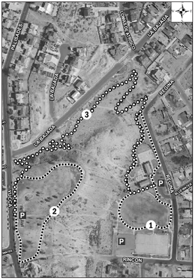
Pat Hurley Park has two developed areas. They are connected by a paved path that winds up the hill. The lower loop circles the Community Center and playground. The upper loop circles grass playfields and a small playground. Combine all the trails for a walk of 1.1 mile.
Nearby major cross streets:
Yucca Rd. & Central Ave. SW
ABQ Ride Stops:
#66, #766
Public Facilities:
Community Center
Parking:
Each developed area has accessible parking
Print this information out and take it with you!Click to see a bigger image.
1) Lower Loop
Trail Distance: .36 mile
Difficulty: Grade 1
Steps: 740
Trail Surface: 4–6 feet concrete
Attractions: Benches, resting areas, connections to tennis courts, playgrounds

2) Upper Loop
Trail Distance: .33 mile
Difficulty: Grade 1
Steps: 700
Trail Surface: 4–6 feet wide concrete
Attractions: Benches, resting areas, small play area, good visibility of other park and trail use, great views of Albuquerque’s skyline
3) Climbing Trail
Trail Distance: .6 mile
Difficulty: Grade 3
Steps: 1270
Trail Surface: 4–6 feet wide asphalt, steep grade of 8% or more
Attractions: Many resting areas

