

Tijeras Cultural Corridor
Jump to the Spanish Translations of the Signs | Letreros Traducidos al Españoll
 The City of Albuquerque Open Space Division developed the Tijeras Creek Cultural Corridor Plan (TCCC), a multijurisdictional project that spans portions of the Tijeras watershed. It starts at the City’s Singing Arrow Community Center and archaeological site and heads east to include the City’s Open Space Route 66 and the Tijeras Education Center and further to the Carnué Land Grant Hall, Bernalillo County Open Space Tijeras Remediation Site, and Village of Tijeras Camino Primera Agua Park. Each of these locations features education signs. The public is encouraged to visit each location to fully explore and learn about the importance of this area, including its ecological, historical, and cultural significance. Additionally, many places of interest are highlighted beyond these key sites for additional adventures.
TCCC Mission: Protect the living cultural landscape of the Tijeras Watershed for current and future generations by creating a sense of place through oral histories, landscape, and relationships between land, animals, water, and people.
Story Map
This story map uses geographic information to tell the story of the TCCC. This is a living document that may change over time and covers such topics as geology, flora and fauna, peoples and places and settlement of the area. Take time to virtually learn about the TCCC and discover how you are part of this story.

Visit the Tijeras Creek Cultural Corridor Story Map Site
Tijeras Arroyo Biological Zone Resource Management Plan
The Tijeras Arroyo is nestled between the Sandia and Manzano Mountains and encompasses a rich living history and diversity of vegetation, including large Cottonwood trees and willows. In 2014, the City of Albuquerque adopted a Resource Management Plan for the Tijeras Arroyo Biological Zone (Bio-Zone) due to its significance as a sensitive riparian area that provides critical habitat and a corridor for wildlife; aquifer recharge and tributary to the Rio Grande; and major historical and cultural site that connects Albuquerque to the East Mountains and larger grassland of the Great Plains to the east. The plan is available online.
The plan outlines the area’s importance and makes a case for why the City should prioritize a 3.7-mile stretch of the Tijeras Arroyo for acquisition and designation as a Major Public Open Space. Additionally, this area was included in City Council Resolution R-16-12, which prioritized significant areas to purchase for protection. Since 2018, the City has acquired 170 acres identified in these processes. The two most recent acquisitions include a historic 8.4-acre parcel that will be co-managed with the Cañón de Carnué Land Grant and the 25-acre home of the in-progress Tijeras Bio-Zone Center. The Center will enable the City to engage youth and families in meaningful programs connected to the Bio-Zone. This work has already begun in partnership with Ciudad Soil and Water Conservation District.
This corridor historically and currently serves as a nexus of movement for vital resources and cultural exchanges to and from Albuquerque and now includes the historic Route 66 and Interstate 40. Preserving this area allows us to protect and celebrate the stories, culture, and traditions of the East Mountains communities irrevocably intertwined with Albuquerque and the unique riparian environment supporting abundant wildlife.
Tijeras Bio-Zone Center: Planning and Restoration Efforts Underway
The Open Space Division (OSD) is collaborating with the Ciudad Soil and Conservation District (CIUDAD) to enhance public programming and land restoration at the Tijeras Bio-Zone Center. CIUDAD has received $581,531 through three grants aimed at implementing stream restoration, floodplain improvements, and the design and construction of an ADA sensory trail and Education Center.
To ensure the project's success, OSD is working alongside various organizations, each bringing valuable expertise to the table, including:
- Hero’s Path Palliative Care (home-based pediatric palliative care)
- Nature Matters
- Talking Talons (youth environmental education and leadership programs)
- AMP Concerts (community concerts)
- NM Volunteers for the Outdoors (restoration and trail-building)
These collaborations aim to create a dynamic and accessible environment that benefits the community and supports ecological restoration efforts.
Public Input - Education Center
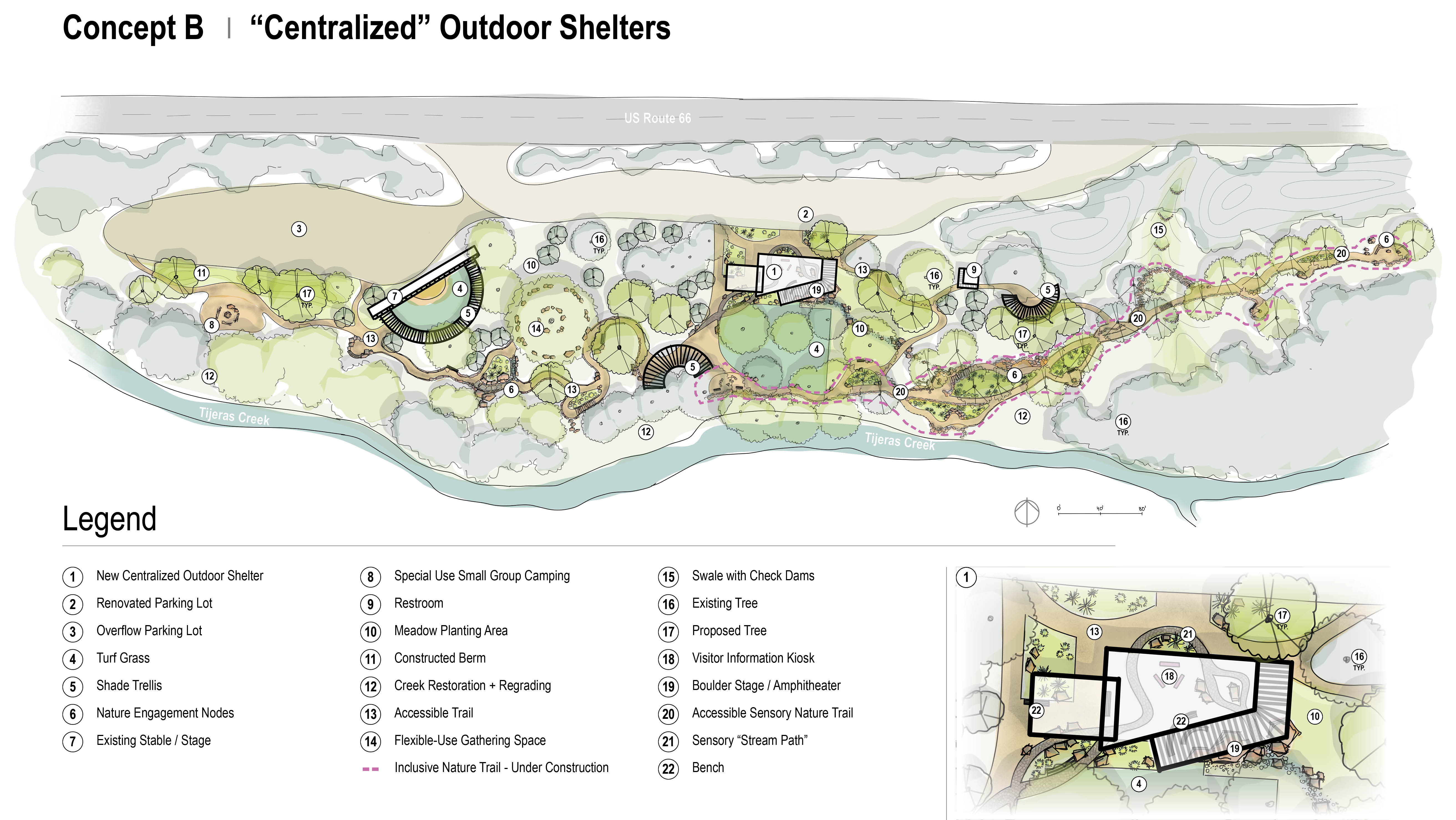
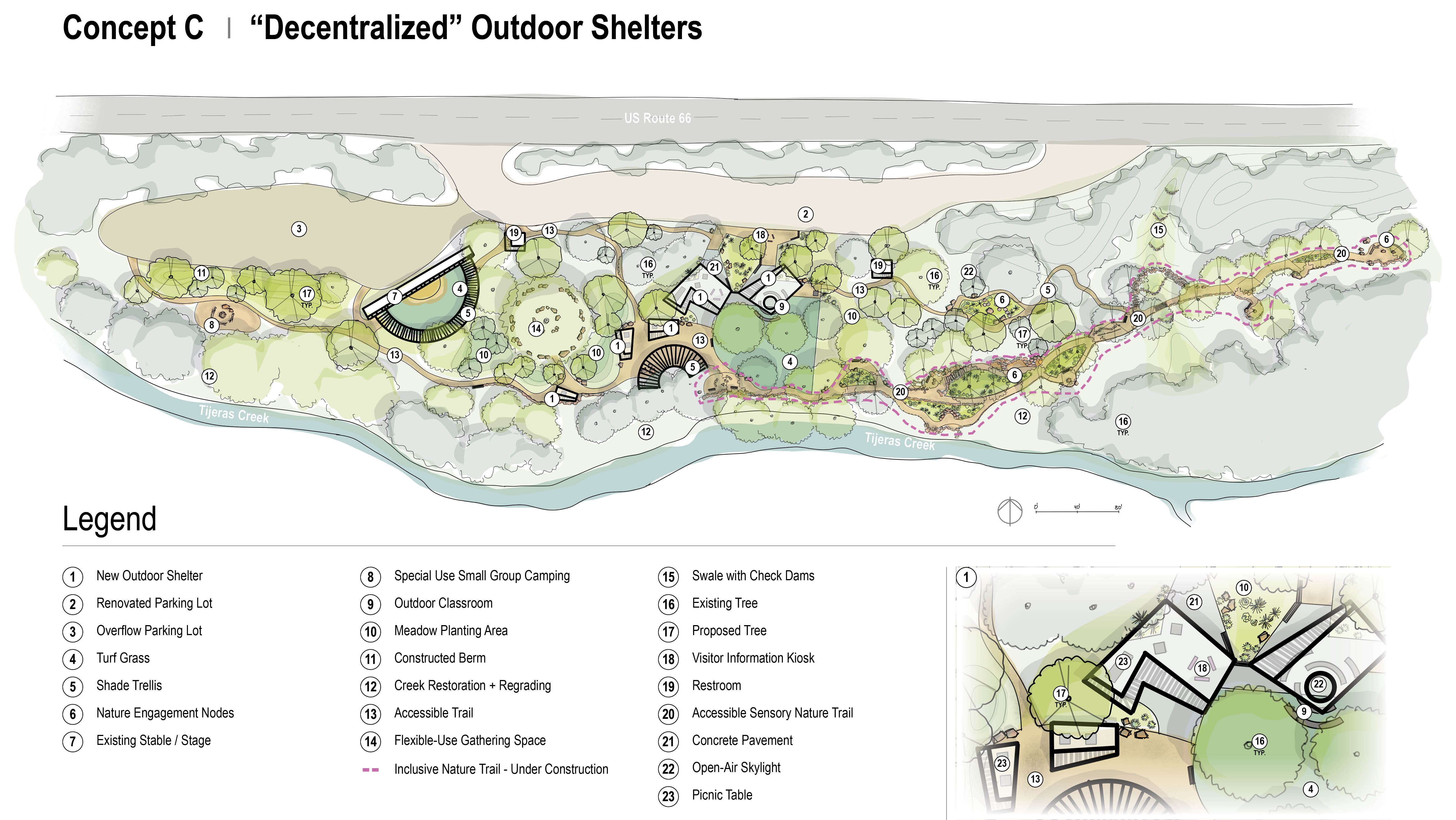
On September 19, 2024, a community meeting was held to gather feedback on the Tijeras Bio-Zone Education Center. Under contract with the City, Pland Collaborative presented three conceptual design options (Concepts A-C, linked below). Due to the project site being located in a floodplain, there are constraints on what kind of structure(s) can be built on the property. Each of the concepts addresses this by showing alternative options for a gathering/classroom structure.
Site analysis/Existing conditions
Concept A: shows a traditional new building in place of the old building
Concept B: shows a series of shade structures that are concentrated in one central area
Concept C: shows a series of separate shade structures of different sizes that are separated/decentralized
Share Your Thoughts
Your input is valuable in shaping the future of the Tijeras Bio-Zone Education Center! We invite you to review the design concepts and share your feedback through our survey: Tijeras Biozone Education Center.
Guided Tours and Volunteering
OSD and its partners offer guided tours upon request and will begin hosting monthly public tours. To learn more about volunteering or to get involved, contact [email protected] or call 505-768-4200.
Route 66 Open Space: Planned Public Access
The Open Space Division developed a site plan for the Route 66 property, approved by the Environmental Planning Commission in January 2024. The site plan includes equestrian parking, an accessible hilltop accessible trail, educational signage, shade structures, picnic tables, and other amenities. This property is the main public parking and trailhead to a trail system that extends to Manzano Four-Hills and throughout the Tijeras Bio-Zone. The property is under construction and is anticipated to open to the public in the summer of 2025. View the draft site plan construction drawing.
Spanish Sign Translations
Looking for a translation for a physical sign and scanned a QR code? Please click the location of the sign below to see the translation.
- El Centro Communitario Signing Arrow | Singing Arrow Community Center
- Moviéndose con el Rebaño | Singing Arrow Park - Moving the Herd
- Las Raíces de la Ruta 66 y Fuerzas Poderosas | The Roots of Route 66 and Powerful Forces
- Explorando el Centro Educativo Tijeras Bio-Zone | Tijeras Bio-Zone Education Center
- Canon de Carnué | Carnué Land Grant Hall
- Agua: El Corazón de Nuestras Comunidades | Water: The Heart of Our Communities
- Una Despensa Viva | Camino Primera Agua Park - A Living Larder