2022 City Council Redistricting Process
Subscribe to our mailing list for updates
Updates
September 19, 2022
At the September 19, 2022 City Council Meeting, the City Council approved O-22-34 on a 7-2 vote. O-22-34 had Concept Map A as the new City Council District boundaries. The new boundaries will go into effect 5 days after publication of the ordinance. We expect the publication to occur within the next three weeks.
September 7, 2022
At the September 7, 2022 City Council Meeting, City Councilors Pat Davis, District 6 and Tammy Fiebelkorn, District 7 shared their proposed amendments to O-22-34 to change the proposed map of City Council Districts.
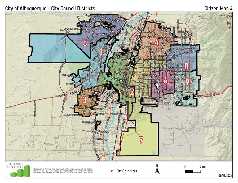
- Councilor Davis amendment to replace Exhibit A with Citizen Map 4.
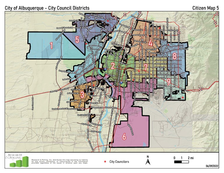
- Councilor Fiebelkorn amendment to replace Exhibit A with Citizen Map 5.
After discussion, the City Council voted to defer the bill O-22-34 to the September 19, 2022 City Council Meeting.
Redistricting Committee Ratings and Report
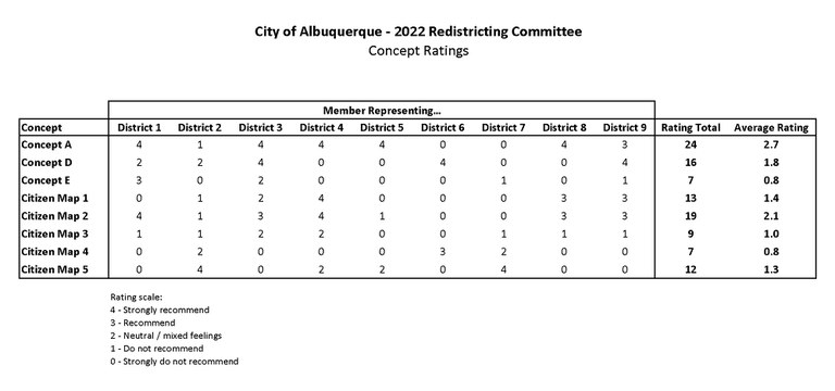
On June 29, 2022, the Redistricting Committee rated the 8 maps: Concept Maps A, D, and E, Citizen Maps 1 through 5. Review the Committee's Ratings below:
The Committee voted to send all 8 maps to the City Council for their consideration. The report was provided to the public and the City Council on July 1, 2022.
Read the Final Report
Legislation for the adoption of the report and the accompanying ordinance to amend the boundaries of the City Council will be on the Letter of Introduction for the August 1, 2022, City Council Meeting. It is anticipated that these two bills will first be heard by the City Council at the Wednesday, September 7, 2022, City Council Meeting. This website will continue to collect public comments, which will be provided to all Councilors for their consideration.
Jump to Concept Maps
Background
Every 10 years, the City Charter requires that the Council appoint a committee composed of an equal number of representatives from each Council District to review and make recommendations regarding redistricting the Council Districts based on information from the Federal Census. The Committee is tasked with using the population data from the official 2020 U.S. Census along with any other pertinent information to make a report recommending changes in the Council District boundaries that the Committee decides are necessary based on constitutional principles governing voting rights, population, compactness and other related factors.
The Committee is made up of 18 members - one voting member and one alternate member from each Council District. The Council is required, in appointing a committee that "as nearly as is practicable" be a fair and balanced representation of all geographical areas of the City in the redistricting process and provide a total membership that reflects the racial, ethnic and gender makeup of the City's population.
All meetings of the 2020 Redistricting Committee are subject to the State Open Meetings Act.
The 2022 Redistricting committee was established via R-21-226 and the members appointed via OC-22-1. Per R-21-226, the committee will begin meeting in March 2022, with recommendations due to City Council by July 1st, 2022.
2022 Redistricting Committee Meetings
The 2022 Redistricting Committee will be meeting twice a month via Zoom on the following dates at 5:30p.m. A total of 8 meetings are scheduled, (6 regular meetings and two “as needed” meetings):
- March: March 9th and 23rd
- April: April 6th and 27th
- May: May 4th and 18th
- June: June 8th and 29th
Meeting Information
| DATE | AGENDA | Materials | Zoom | YouTube | Minutes |
|---|---|---|---|---|---|
|
March 9, 2022 5:30 PM |
Agenda |
Webinar ID: 827 3745 0845 |
|||
|
March 23, 2022 5:30 PM |
Presentation |
Webinar ID: 871 8592 2603 |
Watch | ||
|
April 6, 2022 5:30 PM |
Webinar ID: 813 9654 6044 |
|
|||
|
April 27, 2022 5:30 PM |
Webinar ID: 886 3237 3395 |
||||
|
May 4, 2022 5:30 PM |
|
Webinar ID: 864 7663 9027 |
|||
|
May 18, 2022 5:30 PM |
|
Webinar ID: 891 4424 0074
|
|||
|
June 8, 2022 5:30 PM |
|
Webinar ID: 813 5423 7817
|
|||
|
June 29, 2022 5:30 PM |
|
Webinar ID: 861 7328 5493
|
2022 Redistricting Committee Materials
Concept Maps
Jump to Concept Maps
Current Map | Concept Map A | Concept Map B | Concept Map C | Concept Map D
Concept Map E | Citizen Map 1 | Citizen Map 2 | Citizen Map 3 | Citizen Map 4 | Citizen Map 5
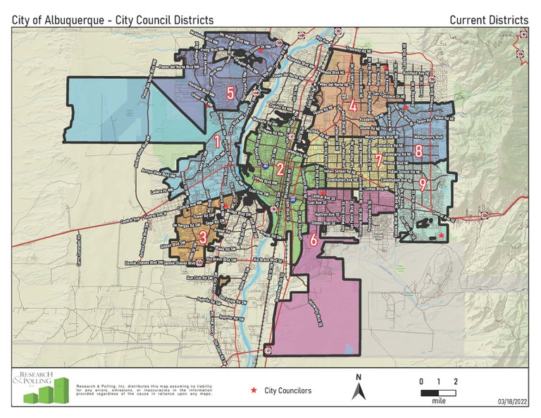
Current City Council Districts
Current Map PDF | Shapefile | Districtr
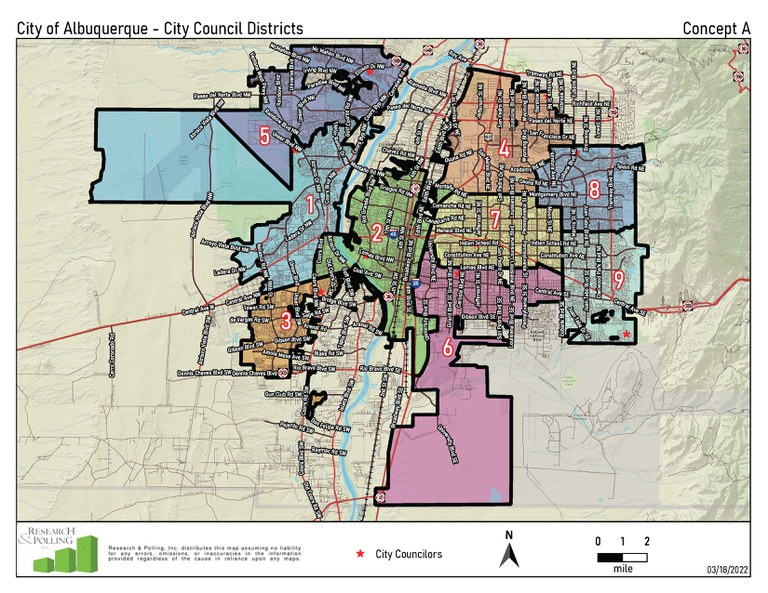
Concept Map A
Concept Map A PDF | Shapefile | Districtr
Objective: Minimal change plan to account for population changes and minimize voter confusion.
Incumbent pairings: none
Identical to current districts with respect to Districts 3, 4, & 9
- District 5 had to lose population. Its boundary with District 1 moves north to the bluff south of the Petroglyph Estates.
- District 2 crosses the river between Central and I-40 to Coors taking the West Mesa and Pat Hurley neighborhoods from District 1.
- District 6 moves west into District 2 from Buena Vista to I-25 between Gibson and Lomas. District 6 also takes the University West area (including Carrie Tingley Hospital) from District 2.
- District 7 moves south into District 2 from I-40 to Lomas between I-25 and Carlisle not including the University West area.
- District 8 moves into District 7 from Montgomery to Comanche between Wyoming and Eubank.
Concept Map B - Committee Voted to Eliminate Map
Concept Map B PDF | Shapefile | Districtr
Concept Map C - Committee Voted to Eliminate Map
Concept Map C PDF | Shapefile | Districtr
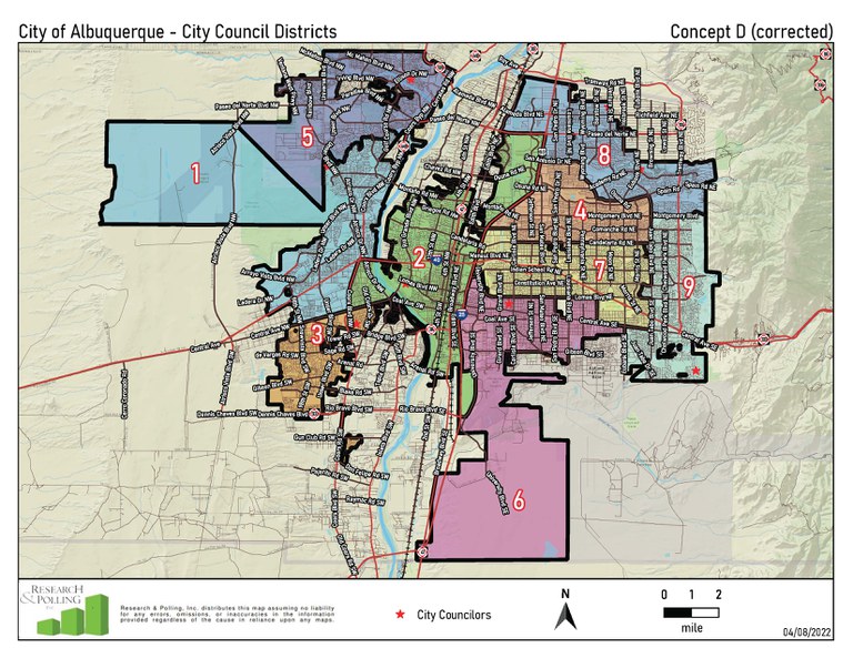
Concept Map D
Corrected version - original version had a table showing a district with a deviation greater than 5% (District 4 at -5.9%), corrected concept fixes that by moving one precinct from District 8 to 4
Concept Map D PDF | Shapefile | Districtr
Objective: Provide a different orientation of the eastside districts by creating a foothills district and a far NE Heights district.
Incumbent pairings: incumbents from District 4 and District 8 paired in District 8
Identical to Concept A with respect to Districts 1, 3, & 5
- District 9 becomes a Four Hills/foothills district. Follows Juan Tabo to Montgomery. Basically goes from Four Hills to El Dorado High School.
- District 8 becomes a far NE Heights district. From the east side of the city, the southern boundary follows Montgomery to Juan Tabo, then follows Spain to Wyoming, up to San Antonio, then follows San Antonio to I-25 then crosses I-25 along Paseo del Norte.
- District 4 takes everything south of District 8 and north of Candelaria between Juan Tabo and I-25 except for the neighborhoods between Comanche and Candelaria and Carlisle and I-25 which go into District 7.
- District 7 mostly takes everything between I-25 and Juan Tabo south of District 4 and north of Lomas. District 7 does not include University West (which is in District 6) and does go south of Lomas to Central between Wyoming and Juan Tabo.
- District 6 stays mostly south of Lomas except for University West and runs from I-25 in the west to Wyoming in the east. South of Central, District 6 goes to Eubank.
- District 2 crosses the river to Coors between Central and I-40 and stays west of I-25. Moves north into District 4 to Paseo del Norte.
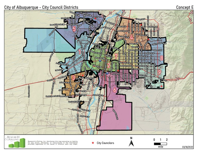
Concept Map E
Concept Map E PDF | Shapefile | Districtr
Objective: Redistribute the downtown area between two districts (Districts 2 & 6).
Incumbent pairings: incumbents from District 2 and District 6 paired in District 2
Identical to Concept A with respect to Districts 1 & 5.
On the east side of the city, the districts all move a little clockwise so that District 6 can come into Barelas and the southern part of downtown.
- District 2 crosses the river to Coors between I-40 and Central and to the ditch south of Central. The southern boundary of District 2 stays mostly along Central east of the river. District 2 stays west of I-25 north of I-40 and west of Carlisle between I-40 and Central. District 2 moves north into District 4 from Montaño to Osuna west of I-25.
- District 6 stays south of Central west of Carlisle and south of Lomas between Carlisle and Wyoming.
- District 9 moves west from Eubank to Wyoming, staying south of Indian School.
- District 8 moves south from Menaul to Indian School and west from Eubank to Wyoming.
- District 4 moves into District 8 taking everything north of Montgomery west of Eubank and Juan Tabo.
- District 7 stays west of Wyoming and moves north into District 4 from Montgomery to Academy.
- District 3 stays west of the ditch south of Central.
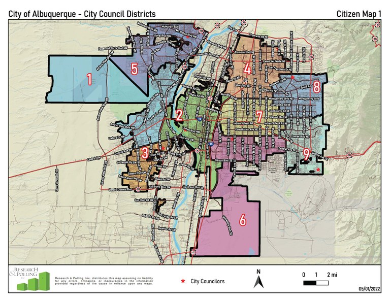
Citizen Map 1
Citizen Map 1 PDF | Shapefile | Districtr
Originally the Scotti Romberg map
Citizen’s Stated Objective: Get the districts more equal in population.
Incumbent pairings: none
Identical to Concept A with respect to Districts 3, 4, 5, & 6
- In contrast to Concept A, the West Bluff area north of I-40 and east of Coors moves from District 1 into District 2
- Compared to Concept A, District 9 moves west into District 7 moving from Eubank to Easterday Dr between Constitution and I-40
- District 8 takes two precincts additional from District 7 between Eubank and Moon and Comanche and Candelaria compared to Concept A
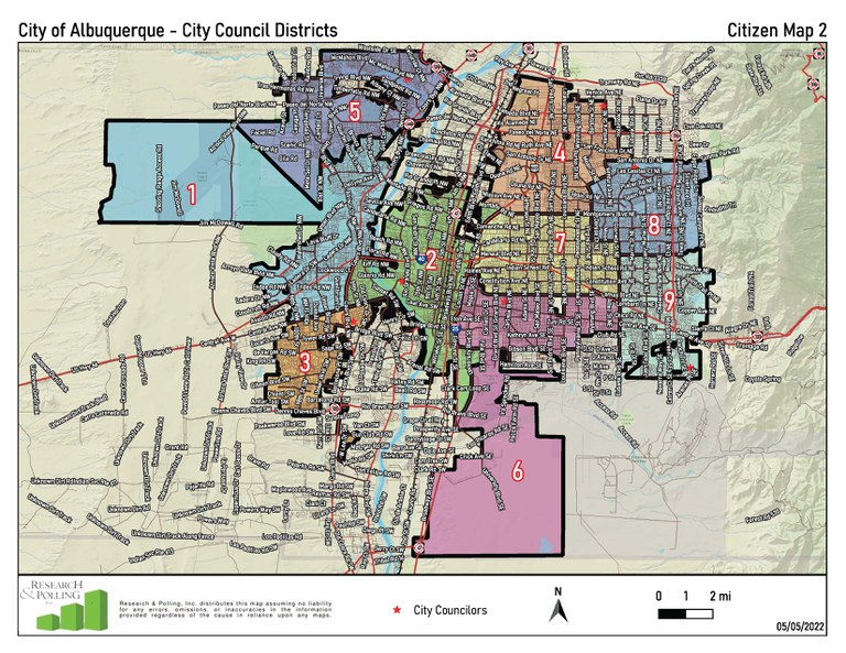
Citizen Map 2
Citizen Map 2 PDF | Shapefile | Districtr
Originally the Skowran map
Citizen’s Stated Objective: Decrease the population deviation in District 8.
Incumbent pairings: none
Identical to Concept A with respect to Districts 1, 2, 3, 4, 5, 6, & 9
- District 8 moves even further south into District 7 than in Concept A to Candelaria between Wyoming and Eubank.
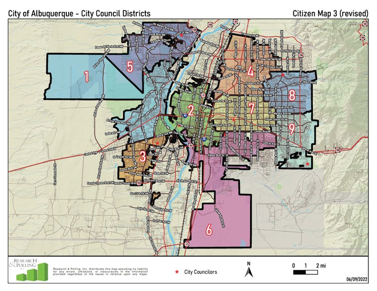
Citizen Map 3
The original Districtr-submitted map was adjusted to correct minor contiguity issues affecting Districts 3 and 6.
Citizen Map 3 PDF | Shapefile | Districtr
Originally the Historic COI Revised map
Citizen’s Stated Objective: Putting the historic core of Albuquerque in a single district (District 2).
Incumbent pairings: none
Identical to Concept A with respect to Districts 1 & 5
Identical to Citizen Map 1 with respect to Districts 8 & 9
Two districts crossing the river – one north of Central to Coors and one south of Central to Atrisco ditch.
- District 2 crosses the river to Coors between Central and I-40 and retains the core of Downtown. District 2 crosses I-25 to Girard between Avenida Cesar Chavez and Lomas. Crosses Lomas to take in University West.
- District 3 stays west of the ditch south of Central.
- District 6 takes the Huning Castle neighborhood and the part of Barelas south of Anderson. The northern and eastern boundaries of District 6 are the same as current boundaries.
- District 4 moves south into District 2 from Montaño to Comanche west of I-25.
Citizen Map 4
Citizen Map 4 PDF | Shapefile | Districtr
Originally the Davis/Fiebelkorn map
Citizen’s Stated Objective: Rethink the orientation of the two mid-heights districts (Districts 6 & 7) without adjusting the other districts.
Incumbent pairings: incumbents from District 6 and District 7 paired in District 7
Identical to Citizen Map 2 with respect to Districts 1, 3, 4, 5, 8, & 9
- District 2 takes the two Kirtland Addition precincts
- Districts 6 and 7 take on a vertical rather than horizontal orientation
- District 6 takes everything south of Menaul between San Mateo and Eubank as well as the neighborhoods between Candelaria and Menaul between Louisiana and Eubank.
- District 7 stays south of Montgomery, east of I-25 and mostly west of San Mateo.
Citizen Map 5
Citizen Map 5 PDF | Shapefile | Districtr
Originally the Fairness for Our Future plan
Citizen’s Stated Objective: Increase representation for the west side and create an additional majority Hispanic district.
Incumbent pairings: incumbents from District 6 and District 7 paired in District 7, incumbent from District 2 moved to District 6
Both Districts 2 & 6 cross the river to Unser between Central and I-40. District 6 takes Barelas. The other districts are similar to current.
- District 5 is very similar to Concept A. District 1 moves a little further north into District 5, keeping District 5 on the negative side of the allowable population deviations.
- District 2 crosses the river to Unser between Los Volcanes and I-40 and takes the two West Bluff precincts north of I-40 and east of Coors. District 2 stays north of Bell between 2nd and Buena Vista. Keeps the Huning Castle neighborhood, but loses the Albuquerque Country Club to District 6. District 2 crosses I-25 to Carlisle into District 7 between I-40 and Montgomery.
- District 6 crosses the river to Unser between Central and Los Volcanes. District 6 also crosses the river south of Central to the ditch. District 6 stays south of Central between Buena Vista and San Mateo and then moves to Lomas between San Mateo<M/span> and Wyoming.
- District 9 moves west from Eubank to Wyoming south of Menaul. District 9 also stays south of Indian School as District 8 moves south.
- District 8 moves south from Menaul to south of Indian School and east from Eubank to Morris. The boundary between Districts 4 & 8 changes slightly with District 8 moving north into District 4 from San Antonio to San Franciso east of Ventura and District 4 moving east into District 8 from Wyoming to Moon between Academy and Spain.
- District 4 moves south into District 7 from Montgomery to Comanche between Carlisle and San Mateo.
- District 7 takes UNM and the north campus area from District 6. District 7 moves south of Lomas to Central between UNM and San Mateo<?span>. District 7 curves around District 9 to Indian School between Eubank and Morris.
Other Documents
Districtr
UPDATE June 8, 2022: The Albuquerque Redistricting Committee is no longer accepting new submissions given the upcoming deadline for providing recommendations to the City Council.
The public can participate in the redistricting process by drawing maps and communities of interest using the tools on this site to draw your own plan, update existing concepts under committee consideration, or let the committee know about your community.
In order for a plan to be considered by the committee, make sure your map fits the following criteria.
- All districts are contiguous – meaning that all precincts assigned to a district are touching at least one other precinct assigned to that district.
- The maximum population deviation does not exceed 5.00% (i.e. does not exceed +/- 5% deviation from the ideal population).
The committee will consider a plan (that meets the above criteria) or community of interest submitted on this site, if it is introduced by the creator during the public comment section of a meeting, or if it is introduced via the Public Comments form below, on this webpage. If submitting a plan or community of interest in the form below, please include the plan URL (plan link) in the “Your Comments” box.
2022 Redistricting Committee Membership
The 2022 Redistricting Committee is comprised of the following members:
| Council District & Councilor | Representative | Alternate |
|---|---|---|
|
1 – Councilor Sanchez |
Victor Segura |
Dan Aragon |
|
2 – Councilor Benton |
Keith Romero |
Joaquin Baca |
|
3 – Councilor Peña |
Cherise Quezada |
Luis Hernandez Jr |
|
4 – Councilor Bassan |
Mark Reynolds |
Rebecca Latham |
|
5 – Councilor Lewis |
Steve Smothermon |
Robert Aragon |
|
6 – Councilor Davis |
Cathryn McGill |
Rosendo Najar |
|
7 – Councilor Fiebelkorn |
Travis Kellerman |
Heather Berghmans |
|
8 – Councilor Jones |
David Buchholtz |
Kevin Powers |
|
9 – Councilor Grout |
Kenneth Pascoe |
Thomas R Stull |
2022 Redistricting Committee Contact
Petra Morris, Associate Director of Planning & Policy Development, 505-768-3161, [email protected]
Public Comments
Members of the public can join the Zoom Webinar for each meeting (Agendas and Zoom links are above under Meeting Information) and use the raise hand feature on Zoom to provide live public comments to the Committee.
Written comments can be submitted below and will be distributed Committee Members, City Staff, and Research and Polling. Comments and materials submitted by Tuesday at noon, will be provided to all members and staff before the Wednesday Committee Meeting.


